Background
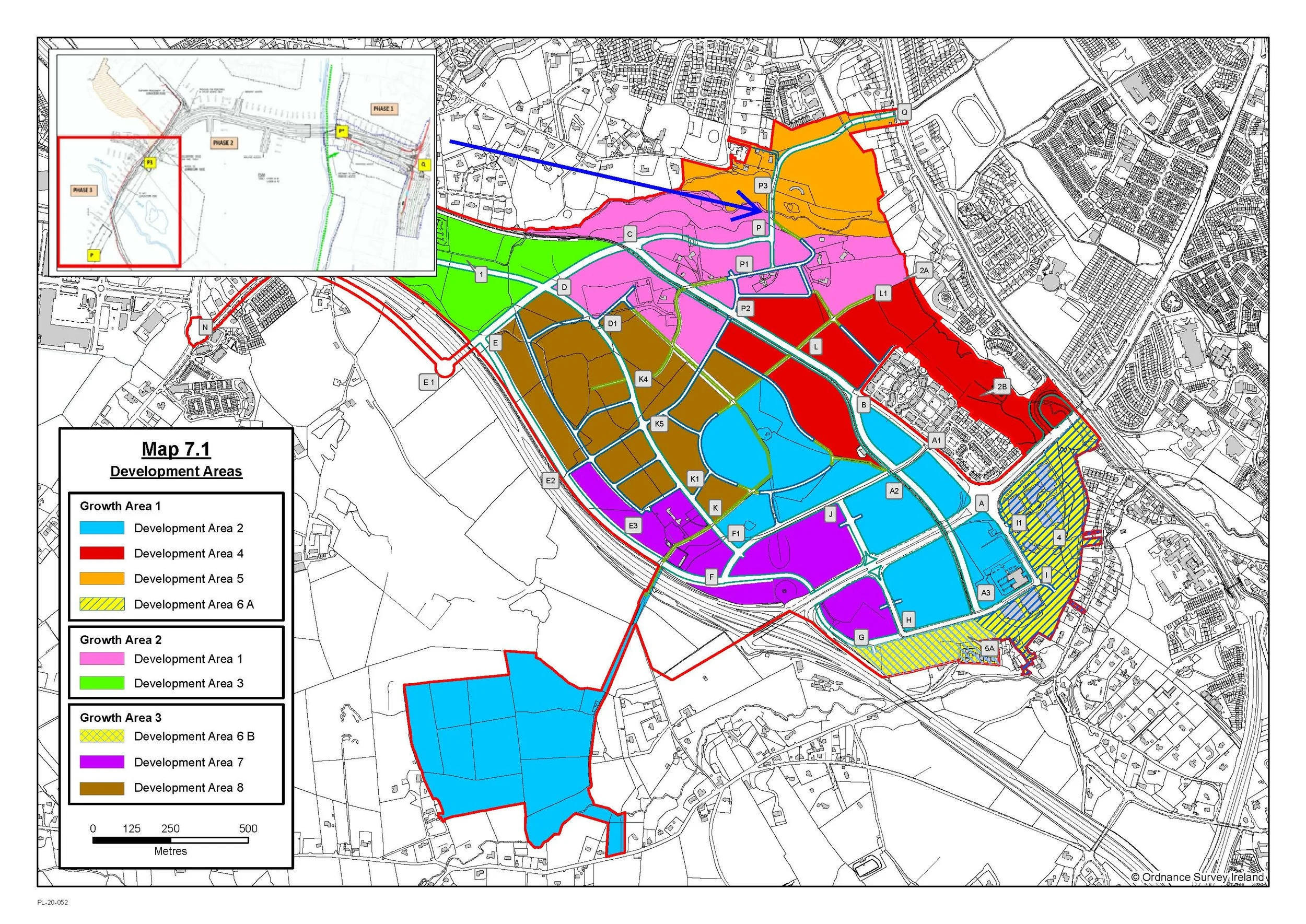
Map of Development Areas of Cherrywood and Planned/Completed Druid’s Glen Road Connections

Location of Cherrywood Planning Scheme within Dún Laoghaire-Rathdown County Council
Cherrywood
The Cherrywood Strategic Development Zone (SDZ) extends to approx. 360 hectares and represents the most significant and strategic development area in Dún Laoghaire-Rathdown County Council. Cherrywood is an emerging new development area that will accommodate 10,500 new homes with a population in the region of 26,000 people. It includes a new mixed-use Town Centre together with employment lands and three smaller Village Centres that will support approximately 22,000 jobs.
The Cherrywood SDZ Planning Scheme was approved by An Bord Pleanála in 2014 having gone through an extensive public consultation. The approved Planning Scheme seeks to unlock Cherrywood’s development potential with a connected transport network that incorporates the Druids Glen Road, which will cross the Carrickmines River and form part of a new strategic east-west route across Cherrywood. In recognition of the strategic importance of the Druid’s Glen Road and crossing, the Planning Scheme limits the numbers of houses that can be occupied before this transport project is completed.
Druid’s Glen Road
Druid’s Glen Road will provide connectivity from the Planning Scheme area to the N11 and will form part of a continuous east-west vehicular and pedestrian connection across Cherrywood, providing essential access to the north-east area of Cherrywood (Development Areas 1 and 5). The pedestrian facilities will link future residents of the area to the emerging Bus Connects services on the N11.
Policy Background

The Cherrywood Planning Scheme (2014, as amended) is the key local policy document identifying the requirement for the Druid’s Glen Road including a bridge. This calls for the construction of a "high-level bridge" linking Development Area 5 (Druid’s Glen) and Development Area 1 (Lehaunstown).
This bridge is identified as a critical piece of infrastructure needed to overcome the physical barrier created by the valley and Carrickmines River, enabling the efficient delivery of housing, transport, and community services within the SDZ.
It emphasises the need for sensitive design that protects the Druid’s Glen ecological corridor while achieving wider sustainable transport and development goals.
Additional policies that have been considered as part of the identification of the Emerging Preferred Concept include:
National policy:
Climate Action Plan 2024 & Climate Action and Low Carbon Development (Amendment) Act 2021
Project Ireland 2040 – National Sustainable Mobility Policy
Regional Policy:
Local Policy:
Cherrywood Area-Wide Travel Plan (2015, updated 2016)
A range of Standards and Guidance documents were also referenced including:
The Design Manual for Urban Roads and Streets (DMURS) (Transport Infrastructure Ireland Publications)
Environmental Setting and Constraints
The Carrickmines River, together with Druid’s Glen Valley, creates a shallow valley at the bridge crossing location. The existing Lehaunstown Lane crosses the river via a small masonry arch bridge. The northern side of the valley features a relatively gentle slope leading down to the river, whereas the southern side has a significantly steeper incline.
The bridge route will pass through the Druid’s Glen Buffer as well as one of the Primary Ecological Corridors within Cherrywood, which includes woodland and riparian habitats. Another key consideration is impact on Surface Water features, Groundwater resources and Flood Risk Zones.
Glendruid House (Protected Structure) is also located in an elevated position on the northern side of Druid’s Glen Valley close to the location for the bridge crossing while the Brennanstown Dolmen (Recorded and National Monument) is located just outside the Cherrywood Planning Scheme lands approximately 0.5 kilometres to the west.
These factors present engineering challenges and require an elevated road crossing that will sensitively cross the terrain while minimising disruption to the environment, ecology, green infrastructure and the visual setting for architectural and archaeological heritage.
It is within this context that the Emerging Preferred Concept presented in the following sections has been informed by Objectives contained in the Cherrywood Planning Scheme, which seek to:
Minimise disturbance to the Druid’s Glen Valley, retain woodland, retain ecological corridors, prevent water pollution, and protect riparian habitats etc.
Protect the setting and views from Glendruid House (Protected Structure); and
Preserve the Valley setting of Brennanstown Dolmen (Recorded and National Monument).